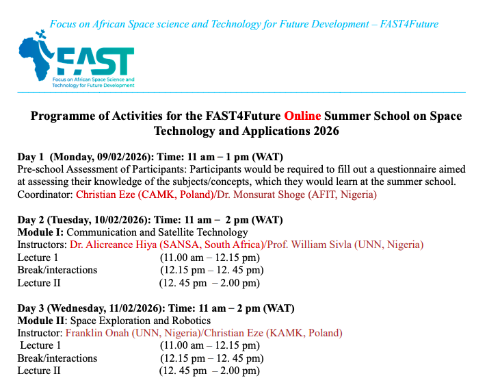
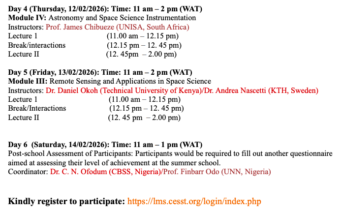
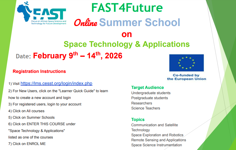
Kindly register to participate: https://lms.cesst.org/login/index.php
https://unn-edu-ng.zoom.us/j/98286783053?pwd=QWK8odhfJX9YagnWOHzVTuib2vPSGa.1
Meeting ID: 982 8678 3053
Passcode: 787600
FAST4Future Launches its Third Synchronous STEM Festival Across Four African Nations
Botswana • South Africa • Zambia • Nigeria — October 6, 2025
In a landmark celebration of science, innovation, and education, the FAST4Future Consortium today hosted a Synchronous STEM Festival that brought together hundreds of students, educators, and researchers across Botswana, South Africa, Zambia, and Nigeria.
The festival, held simultaneously in all four countries, aimed to inspire the next generation of scientists and innovators, with a special emphasis on space science, astronomy, and STEM-driven solutions to societal challenges.
Events were hosted at partner universities and institutions, including the University of Botswana, Botswana International University of Science and Technology (BIUST), the South African National Space Agency (SANSA), the University of Zambia, Copperbelt University, Zambia, and the University of Nigeria Nsuka in Nigeria. Activities ranged from interactive science exhibitions, demonstrations, space-science talks, student competitions, and hands-on experiments, to career mentorship sessions led by African scientists and engineers.
The FAST4Future project, funded by the European Union, aims to empower African youth through space science, astronomy, and advanced STEM education. By linking science outreach with research, the project highlights how space-age tools can tackle real-world problems in health, climate, and innovation.
“Today’s synchronous festival embodies our belief that Africa’s future in space science and technology is bright, collaborative, and inclusive,” said Prof. Taye Demissie, Chair of the FAST4Future Dissemination and Outreach Committee. “By inspiring young minds across borders, we are igniting curiosity and building a pipeline of future innovators.”
Students from secondary schools, science clubs, and community academies participated enthusiastically, studying about astronomy projects in Africa, environmental sensors, and coding skills. The festival also underscored the role of partnerships among African universities, governments, private sectors, and international agencies in strengthening Africa’s role in the global STEM ecosystem.
For photos, highlights, and livestream replays, visit: https://cesst.org and follow the hashtags #FAST4Future #STEMFestival2025 #AfricaInSpace.
Applications are invited from African nationals for scholarships in the fields of Astronomy, Astrophysics, Space and Planetary Science, Planetary Geology and Remote Sensing.


Dear all,I’d like to share two things with everyone.The first is that our space mission, Mission237 #1, is in its design phase. This phase will end at the end of October 2025.I’d like to invite everyone to join and invite your networks to join our WhatsApp community and participate. It is really exciting.Here is the URL: https://chat.whatsapp.com/DILmtTaNvwFIVVahfamBJZThis is run by our non-profit NMD ASSOCIATION.Here is the URL: https://npo.nanosatellitemissions.com/Feel free to join and invite your network to become members of the non-profit. You can join directly on the website.Here is the URL: https://npo.nanosatellitemissions.com/become-member. At the very least, becoming a member will contribute to our fund-raising efforts to achieve this historic leap forward for Africa.The second is the masterclass I am running this weekend (Apologies for the short notice) on IDM-CIC, which is the tool used by the French space agency (CNES) to design satellites.If you could, it would be great to share within your network with those whom you think might find value in it the way you did.The format is simple:
- 2 days (20th and 21st of September) intense with pre-recorded content and tutorials.
- 1 week (22nd to 27th of September) exchange on practical tasks within our WhatsApp community.
Here is the registration link: https://learning.nanosatellitemissions.com/en/course/course_1757506687142Do not hesitate to contact me if you need any additional information.Thanks so much for your support.Kind regards,Ifriky
From Space to Solutions: Using Satellites and AI to Monitor Our Changing Planet
By Associate Professor Andrea Nascetti
Royal Institute of Technology (KTH), Stockholm
Abstract
Every day, satellites orbiting Earth capture an enormous stream of images and measurements that help us see how our planet is changing. Thanks to recent advances in artificial intelligence, we now have powerful tools to analyze and make sense of this “big data from space.” In this seminar, we will explore how these data are collected by modern satellite constellations. We will discuss how new AI models allow us to track urban growth, map disasters such as wildfires and floods, and monitor sensitive environments like glaciers and forests. Finally, we will show how combining satellite observations with AI not only reveals changes more clearly and quickly but also supports better decision-making processes.
Biography
Andrea Nascetti is an Associate Professor at the Royal Institute of Technology (KTH), Stockholm. His research lies at the intersection of remote sensing and computer vision, focusing on developing novel methods for Earth observation and geospatial data analysis. He has worked extensively on applications ranging from urban monitoring and disaster mapping to glacier and forest carbon studies. Andrea also teaches courses in Remote Sensing and Geospatial AI and supervises PhD students. His work bridges cutting-edge data science with real-world environmental and societal challenges.
Time: Sep 23, 2025 11:00 AM West Central Africa
Join Zoom Meeting
https://unn-edu-ng.zoom.us/j/97614768021?pwd=kmbjXG2qFCgpXzw0CS9R4UugfM5R4h.1
Meeting ID: 976 1476 8021
Passcode: 814577
Botswana is set to take centre stage in Africa’s scientific community as it proudly hosts the African Astronomical Society (AfAS) Conference. Scheduled from the 23rd to the 27th of March 2026, the conference will take place in Kasane. This is a scenic town in the northern part of the country that serves as a gateway to the Chobe National Park, a home to one of the largest elephant populations in Africa. Moreover, Kasane is located along the Chobe River, near the Kazungula Quadripoint where the borders of Botswana, Namibia, Zambia and Zimbabwe converge.
This landmark event will bring together leading astronomers, engineers, educators, and policy makers from across Africa and the world to engage in groundbreaking discussions that will shape the future of astronomy and space science on the continent. The AfAS Conference is more than just a gathering of experts—it is a platform for collaboration, innovation, and inspiration. Delegates will exchange knowledge on cutting-edge research, explore new technological opportunities, and foster partnerships that drive scientific progress. For Botswana, the conference represents an unparalleled opportunity to showcase its growing role in astronomy and innovation, with the country building its first radio astronomy observatory at the Botswana International University of Science and Technology (BIUST).
Beyond science, the conference will also highlight how astronomy contributes to socio-economic growth, skills development, and education. Students and young professionals will have the chance to learn directly from world leaders in the field, while industries and policymakers will explore how investment in science and technology drives sustainable development.
By attending the AfAS 2026 Conference in Botswana, participants will not only be part of a vibrant scientific dialogue but also experience the warmth of Botswana’s culture, heritage, and hospitality. Beyond the conference halls, delegates can immerse themselves in the country’s fast-growing astro-tourism scene—combining stargazing under some of the clearest skies in the world with astrophotography experiences and sessions on indigenous astronomy knowledge. Botswana’s unique blend of science, nature, and adventure offers an experience unlike any other. Together, we will advance Africa’s place in global astronomy and inspire the next generation of innovators.
Join them in Botswana for AfAS 2026 where science, innovation, and opportunity will converge.
For more information contact Dr Fahmi Mokhupuki, mokhupukif [at] biust [dot] ac [dot] bw.

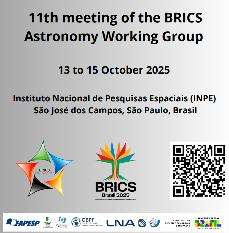
The BRICS Astronomy Working Group Workshop will take place from 13–17 October at the National Institute for Space Research in São José dos Campos, near São Paulo, Brazil and online.
The first two days will be dedicated to the science meeting, while the remaining three days will focus on the BAWG business meeting and societal benefit programmes, including outreach activities, Heliophysics Capacity Building, and Virtual Observatory Training.
This notice is a Call for Abstracts from those wanting to present a contributed talk or poster at the workshop in the following tracks:
- Scientific lectures
- Lectures on education, development, and science outreach
- BRICS Astronomy Working Group meeting
- Virtual Observatory training
- Scientific communication training
- Overview of INPE’s space weather program